Wednesday, January 30, 2013

$42 WI-FI Solution for the Nikon D4

If any of you D4 owners are frustrated by the hefty price tag of Nikon's WT-5 ($550), you're not alone.  I did a considerable amount of research and learned that other options existed.  So here's my less expensive work around solution.  Hope it helps.

For $42, TP-Link sells a Portable Battery Powered Wireless N Router.  I bought mine on Amazon here.


I set this up in basically three steps.  First, I configured the router via directions that came with it.  IMPORTANT - I set it up in Travel Router AP Mode.  I initially set it up for Wireless Router Mode but that didn't work.

I then connected the (powered on) router's ethernet cable to the camera.

Next I created a new Network Profile in the D4 menu.  I used the wizard and let it find the IP automatically.  Write down that IP address, you'll need it later.


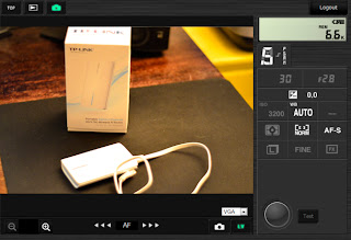
Once this was all connected I used Safari on my iPad to connect to the D4's IP address (the number that I wrote down earlier).  You can also use an iPhone or a laptop, I'm assuming.  If successful, you'll see the camera's built in camera control software like this:


Here you can control the camera in Live View, view images, change camera settings, etc.  Cool!

The best part about this is the ability to view high res (large) images of photos that I've just taken.  This helps a ton when I'm out shooting, especially when a client is present.

Good luck and hope this helps!

Monday, January 28, 2013

Disneyland/California Adventure

We took a family vacation a few months ago to Disneyland to check out the new Cars Land attraction.  Disney has the whole theme building thing down to a science, and no where is that more apparent than in California Adventure.  Since the attraction was brand new, the  lines were about 3 hours long, and that was with a FastPass.

Cars Land at DCA
All about the details...

The layout of Cars Land: Main Street of Radiator Springs, USA from the movie Cars

Disney's California Adventure - kinda looks like the Santa Monica Pier back in the day.
This area in DCA is themed after Fisherman's Wharf in SF
Roaring waters in the back of DCA - the whole area looks like the California Redwoods
(Probably a maintenance building.  I thought it was cool.)

And of course we didn't miss the classics...

Yoho
My D7000 did a pretty darn good job in this low light.  Wish I would have had my D4 at the time!
I'm a real boy.
 
Vision.
Classic.

Monday, January 21, 2013

Turf's Up! Father and son bet the ponies.

It's never too early to introduce your kids to gambling, and the horse track is a as good as any place to do it.  Keg beer, cigars, $1 hot dogs and lost wages - what else do you need?

It was "Family Day" at Turf Paradise today in Phoenix, a place that I don't frequent nearly enough.  Basically a time warp strait back to 1977,  its a fun place to get some sun and play some numbers.  Remember: Gambling is only an addiction if you're losing.

Come on #3!


Fast shutter - this was shot at 1/2500th of a second

A panning shot - didn't come out great and neither did my quinella

Two manes.  This horse could talk.

Turf Paradise is located at 17th Ave/Bell.  http://www.turfparadise.com/

Sunday, January 20, 2013

White Tank Mountain Regional Park

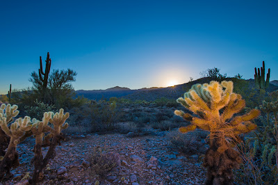
I've had a lot of fun over the years hiking around this area, close to where I grew up.  Its pretty classic Arizona desert terrain - chollas, saguaros, mesquite.  This is the only place I've ever seen a Gila Monster in the wild.  You don't want to get bit by one of those.

Almost Sunset

Nearly 30,000 acres makes this the largest regional park in Maricopa County. Most of the park is made up of the rugged and beautiful White Tank Mountains on the Valleys west side. The range, deeply serrated with ridges and canyons, rises sharply from its base to peak at over 4,000 feet. Infrequent heavy rains cause flash floodwaters to plunge through the canyons and pour onto the plain. These torrential flows, pouring down chutes and dropping off ledges, have scoured out a series of depressions, or tanks, in the white granite rock below, thus giving the mountains their name.

Ancient Arizonans pecked hundreds of figures and symbols on the rock faces of the White Tank Mountains. Some may approach 10,000 years old. All have withstood sun, rain, and vandals for 700 or 800 years or more.


Eleven archaeological sites, occupied during the time period A.D. 500-1100, were located within the boundaries of White Tank Mountain Regional Park. All of these sites can be attributed to the Hohokam Indians. The White Tanks were apparently abandoned by the Hohokam about A.D. 1100. There is no further indication of human occupation until the historic period, when the Western Yavapai controlled the area. Due to the ruggedness of the terrain and the difficulty of obtaining water, sites in the White Tank Mountains were restricted to large canyons leading out of the mountains on the east, north and probably west.


A rock drawing was serious business to its maker. While no one can say precisely what most of them "mean", we know they had important functions in the lives of their makers. They were not simply stone-age graffiti. The symbols recorded events and marked locations. They were a magical way to control nature so rain would fall or mountain sheep would let themselves be caught. Some served as trail markers and maps. Others represented religious concepts.


Most of the sites in the area are concentrated around the White Tanks themselves. The Tanks probably held water the year-round and thereby drew people to the region. Petroglyphs on rocks indicate the Indians were more than transients. Pottery shards along the Agua Fria and Hassayampa signify the presence of villages and a good possibility that an Indian trail connected the streams with the White Tank long before Europeans came into the area. The discovery of possible agricultural terraces or check dams indicates that farming may have been carried on in the various canyons of the White Tank Mountains, by utilizing seasonal runoff and rain water.


looking up at the "waterfall"


Verbiage Courtesy Maricopa.gov

Sunday, January 6, 2013

Puerto Peñasco - Morúa Estuary


I've been going to the "estuary" for as long as I can remember.  It's one of my favorite places on the planet.  Its basically a large bay that fills and empties with the incoming and outgoing tides of the Sea of Cortéz on a daily basis.  At extreme low tides you can almost walk across it.  I came very close to loosing an ATC once years back as incoming tides nearly stranded me on an island in the middle of the bay.  I believe there are only two homes on the estuary, both of which oyster farms.


Officially the "Morúa Estuary" is a this small (only about 2700 acres) but very important ecosystem hosts over 140 species of endemic and migratory birds that either nest, live, migrate to for the winter, or stop over enroute to destinations further south.  Once a haven for off roaders (yes, like me), it is now protected by motor vehicles which has created a very serene environment to walk or kayak or fish.


An osprey and his catch of the day.  Sorry for the crappy shot - it flew out from behind a bush and startled me. 


Condos were built on the other side of the estuary.


Two vultures - these birds are really really large.


Dogs love the estuary too.


A Long-billed Curlew (a type of Sandpiper) walks along the shore.


Interior of the estuary


Two American Oystercatchers - they are in the right spot - there are two oyster farms located here.  $3 will buy you a dozen oysters pulled right out of the water. 


Catching fish isn't only for the birds - this is what my dad caught on a recent trip:


Sea Trout and Pompano


The kids weren't quite as lucky but they'll keep trying.


Wednesday, January 2, 2013

Organ Pipe National Monument

On our recent trip down to Puerto Penasco I pulled over and took a few photos of the surrounding Sonoran Desert landscape.  Beautiful in its own unique way, it can be a very harsh environment for a number of unique desert southwestern inhabitants including animals and plants, the occasional tourists and their cameras, drug smugglers, border patrol, and immigrants looking for a new and better life.


I probably only walked a few yards off of the highway when I noticed Cholla Cactus thorns embedded in my shoes.  Nasty little boogers.


This area known as Organ Pipe National Monument is home to the most dense population of organ pipe cacti on Earth.


From Wikipedia:

Organ Pipe Cactus National Monument is a U.S. National Monument and UNESCO biosphere reserve located in extreme southern Arizona which shares a border with the Mexican state of Sonora. The park is the only place in the United States where the Organ Pipe Cactus grows wild. Along with Organ Pipe, many other types of cacti, as well as other desert flora native to the Yuma Desert section of the Sonoran Desert region grow here. The Park is a beautiful preservation of the American Southwest.
Land for the graded through the Monument was donated by the Arizona state legislature to the federal government during Prohibition knowing that the north-south road would be improved and make contraband alcohol easier to import from Mexico. In 1937 the land was officially opened as a national monument.[3]
At the north entrance of the park is the city of Why, Arizona; the town of Lukeville, Arizona, sits at the park's southern border. Lukeville is a border crossing point to Sonoyta, Sonora, Mexico.